Havana Weather for September 10-16
Usual convective pattern with slightly cooler winds…
HAVANA TIMES – Atmospheric conditions over western Cuba remain under the typical convective pattern for this stage of the season, coinciding with the climatological peak of hurricane activity in the Atlantic. An upper-level low over the Caribbean Sea, associated with a strong pressure gradient, is maintaining slightly cooler-than-usual trade winds over the capital, while daytime heating continues to favor showers and thunderstorms during the afternoon.
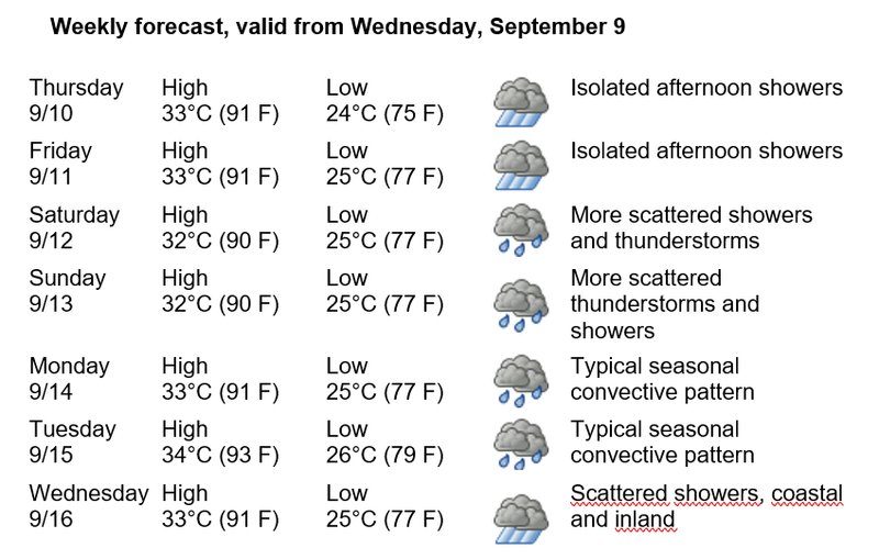
Thursday the 10th and Friday the 11th will see isolated afternoon showers. Saturday the 12th and Sunday the 13th will bring more scattered showers and thunderstorms, with a greater likelihood inland. On Monday the 14th and Tuesday the 15th, the usual convective pattern will continue, while scattered showers are forecast for Wednesday the 16th, mainly in coastal and inland areas of Havana.
Winds will be predominantly from the east and northeast, at speeds of 20 to 40 kilometers per hour (12 to 25 mph), with occasional gusts of up to 50 km/h (31 mph). Relative humidity will remain high, between 60% and 90%. High temperatures will range from 32 to 34°C (90 to 93°F), while lows from 24 to 26°C (75 to 79°F). Sea surface temperatures will remain near 29°C (84°F).
No tropical cyclone development is expected in the Atlantic Ocean, Caribbean Sea, or Gulf of Mexico over the next seven days, according to the latest bulletin from the National Hurricane Center. Cuba’s Insmet continues its routine monitoring appropriate for this period of peak hurricane-season activity.