Havana Weather for July 16 to 22

Hot and afternoon showers persist, with stronger-than-usual winds in the capital…
HAVANA TIMES — Atmospheric conditions over western Cuba continue to be marked by the instability typical of the summer season, with intense daytime heating favoring the development of cloud cover and thunderstorms during the afternoon. A more active-than-usual wind pattern, associated with a strengthening of the easterly and northeasterly flow, will persist over the capital through much of the week.
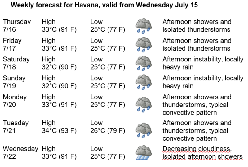
Thursday the 16th and Friday the 17th will follow a pattern similar to today’s, with isolated showers and thunderstorms developing in the afternoon, occurring more frequently inland. Over the weekend, Saturday the 18th and Sunday the 19th, afternoon instability will continue, with the possibility of locally heavy rainfall. On Monday the 20th and Tuesday the 21st, the typical convective pattern will persist, while Wednesday the 22nd is expected to bring a slight decrease in cloud cover, although isolated afternoon showers will still be possible in Havana.
Winds will be predominantly from the east and northeast, with speeds ranging from 20 to 40 kilometers per hour (12 to 25 mph), with gusts that could exceed 45 km/h (28 mph) on several days during the week. Relative humidity will remain high, between 60% and 90%. High temperatures will range between 32 and 34°C (90–93°F), while lows will be between 25 and 26°C (77–79°F). Sea surface temperatures will remain 29°C (84°F).
Across the Atlantic Ocean, Caribbean Sea, and Gulf of Mexico, no tropical cyclone development is expected that would pose a threat to Cuba over the next seven days. Nevertheless, Cuba’s Institute of Meteorology (Insmet) continues its routine monitoring throughout the Atlantic hurricane season, which runs from June 1 through November 30.