Havana Weather for September 3-9
Heavy rains at the beginning of the week due to a depression, with gradual improvement toward the weekend…
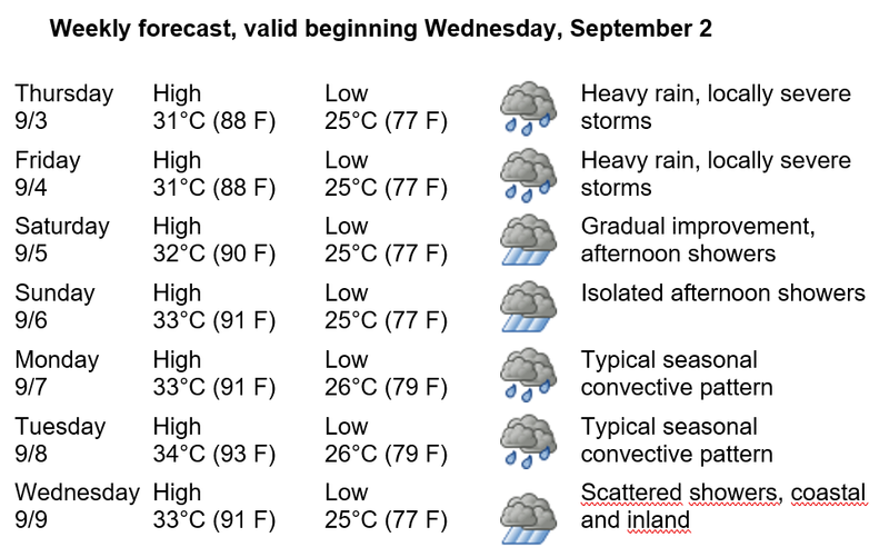
HAVANA TIMES – Atmospheric conditions over western Cuba at the beginning of the week will be influenced by the presence of a trough and an upper-level low near the western region. Combined with high relative humidity and intense daytime heating, these conditions will bring heavy and locally intense rainfall to the capital, with the possibility of severe local storms. Toward the weekend, a gradual return to the typical convective pattern for this time of year is expected.
Thursday the 3rd and Friday the 4th will continue to see heavy rains and thunderstorms, some of them severe during the afternoon and evening hours. Saturday the 5th and Sunday the 6th will bring gradual improvement, with isolated afternoon showers. The usual convective pattern will continue on Monday the 7th and Tuesday the 8th, while scattered showers are forecast for Wednesday the 9th, mainly in coastal and inland areas of Havana.
Winds will be light and variable at the beginning of the forecast week, shifting to the east and northeast at speeds of 15 to 35 kilometers per hour toward the weekend, with occasional gusts of up to 45 km/h during convective activity. Relative humidity will remain high, between 65% and 95%. High temperatures will range from 31 to 34°C (88 to 93°F), while lows from 25 to 26°C (77 to 79°F). Sea surface temperatures will remain near 29°C (84°F).
In the Gulf of Mexico, former Tropical Storm Edouard weakened into a remnant low after making landfall in the United States and poses no threat to Cuba. No tropical cyclone development is expected elsewhere in the Atlantic, Caribbean Sea, or Gulf of Mexico during the next seven days. Insmet continues its routine monitoring appropriate for this period of peak activity in the hurricane season, which reaches its climatological peak in mid-September.